Augmented-Reality in Vassar’s Earth Science Program May 5, 2016
Posted by Jill S. Schneiderman in Uncategorized.Tags: Augmented reality, Topography
1 comment so far
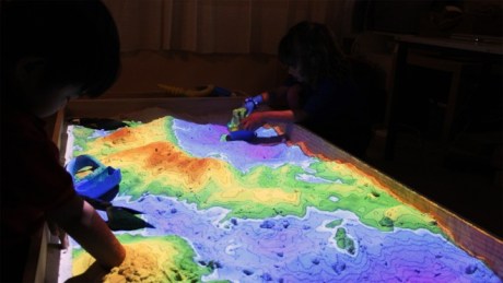
Developed by researchers at UC Davis, these augmented-reality sandboxes teach topography. Photo: Rhys George
It may seem a bit odd for a blog that aims to understand Earth’s truth to tout augmented reality when the actual reality of Earth has plenty to teach. Yet, here in the Earth Science program at Vassar we have an amazing new toy, an augmented-reality sandbox that enables us to mold a 4′ x 4′ box full of play-sand into valleys, mountains and craters. We can watch the transformation of the landscape in real time rather than over the course of millions of years. Our kinesthetic learners can develop landforms in which contour intervals change depending on the proximity of one line of elevation to the next.
And speaking of kinesthetic learners, for geology attracts many of us, check out Sir Ken Robinson’s TED Talk “How to escape education’s Death Valley.” …and come play in a sandbox!
